A Volcano has erupted in How-why-ey spewing lava and causing a mass evacuation.

You are using an out of date browser. It may not display this or other websites correctly.
You should upgrade or use an alternative browser.
You should upgrade or use an alternative browser.
Volcano erupts.
- Thread starter TheFrogger
- Start date
Gawdzilla Sama
Valued Senior Member
Is this the same one that's been erupting for days now?A Volcano has erupted in How-why-ey spewing lava and causing a mass evacuation.
exchemist
Valued Senior Member
Yes, this is a South-Eastern extension of rifts from the main crater of Kilauea. The Hawaiian chain of islands extends North-West from the Big Island where this vulcanism is occurring. This is evidence for the hypothesis that there is a hot spot in the mantle over which the Pacific Plate is gradually moving in a Northwesterly direction, leading to it burning a series of holes which move progressively Southeast with respect to the plate.
It is not unexpected that over time this new eruption location may become more important. However since the rate of movement is only a few cm/yr, this will take centuries.
The Hawaiian lavas are basic in chemical composition (relatively low silica content) and are quite fluid. Generally this allows gases to escape through the magma, resulting in eruptions that are not very explosive in nature. However on this occasion the new rifts seem to have come into contact with groundwater, leading to generation of steam, which seems from the reports I have read to be powering the explosive generation of ash clouds.
Gawdzilla Sama
Valued Senior Member
That steam must be a few thousand PSI.
I heard the laes effect was happening as well?
I heard the laes effect was happening as well?
RainbowSingularity
Valued Senior Member
A Volcano has erupted in How-why-ey spewing lava and causing a mass evacuation.
your pronunciation is wrong
it is pronounced "HA-Wahh-Eieh"
Yazata
Valued Senior Member
Yes, this is a South-Eastern extension of rifts from the main crater of Kilauea.
The main volcano has been deflating as lava has been moving into the rift zone ~30 km east of the main volcano. (The US Geological Survey has sensitive instruments that can measure small rising and falling movements in the ground.) Unfortunately, it's a populated semi-rural area with homes and small farms.
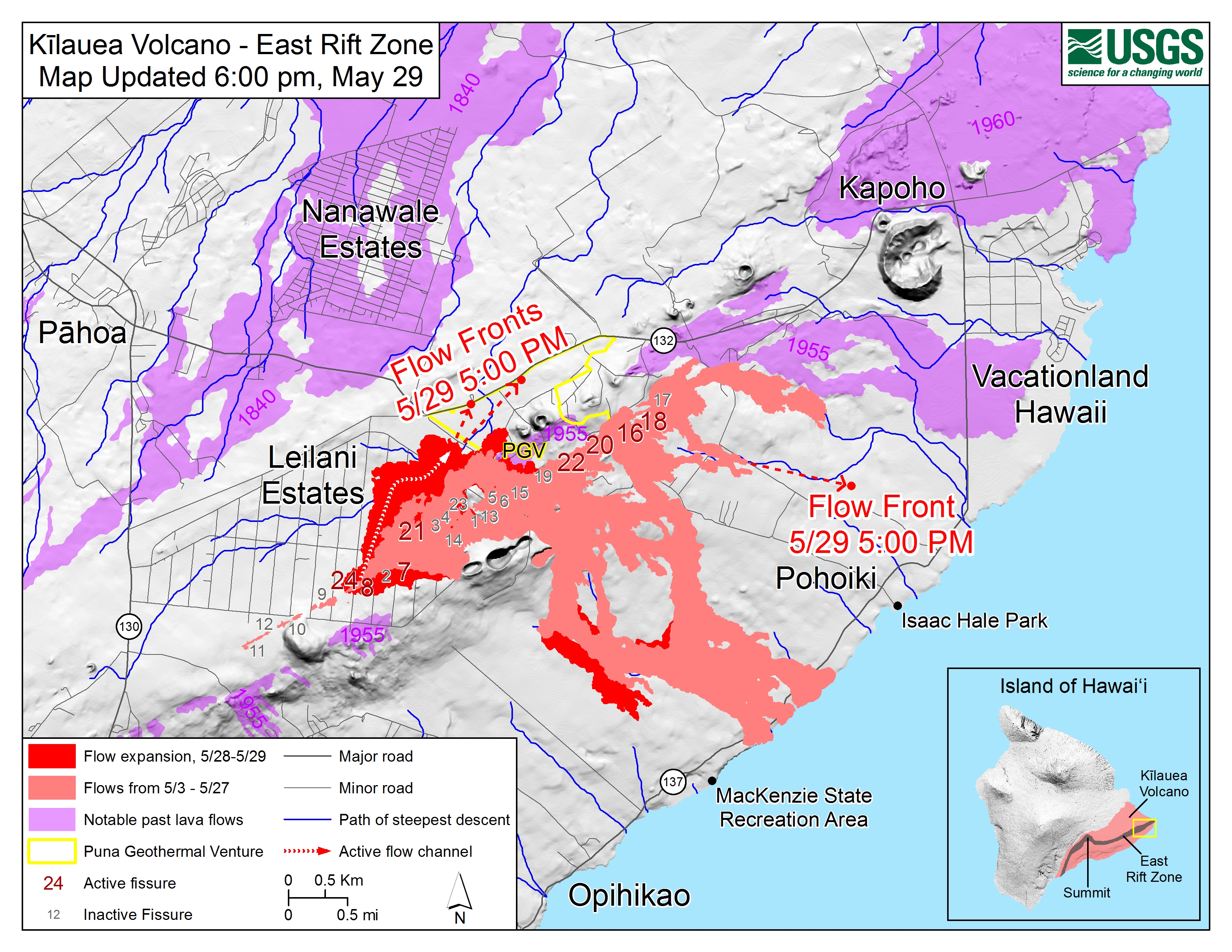
Apparently these movements of lava into the eastern rift area have been happening for some time, since there are lava flows there dating back 200 years and volcanic features like craters and spatter cones older than that. See the map here. (The purple areas are the old flows from previous eruptions.)
Lotsa pretty amazing USGS photos (and videos) at the link below, with descriptive captions, chronicling the whole eruption:
https://volcanoes.usgs.gov/volcanoes/kilauea/multimedia_chronology.html
The Hawaiian lavas are basic in chemical composition (relatively low silica content) and are quite fluid.
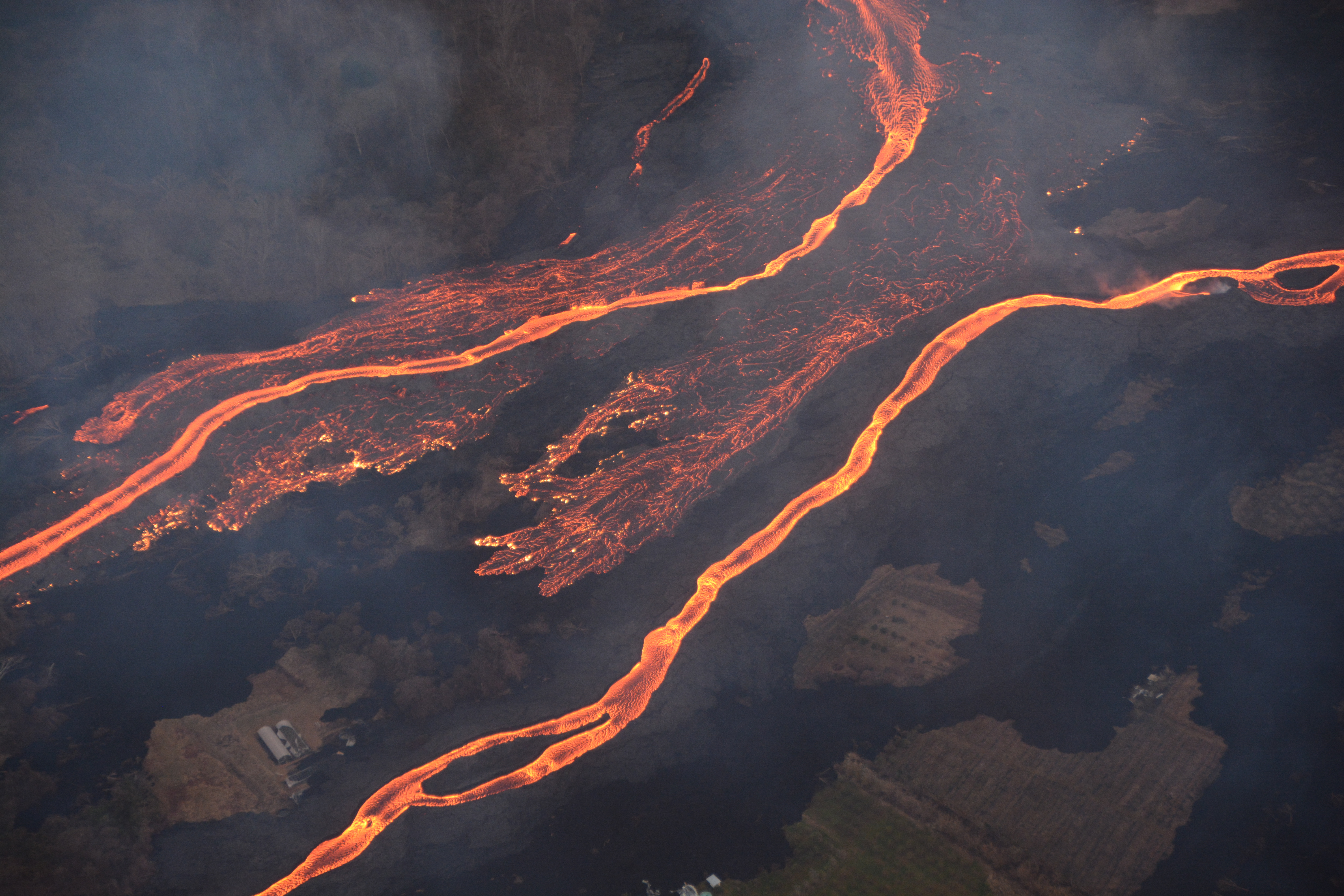
Some of them look like lava rivers (USGS photo).
Last edited:
exchemist
Valued Senior Member
The main volcano has been deflating as lava has been moving into the rift zone ~30 km east of the main volcano. (The US Geological Survey has sensitive instruments that can measure small rising and falling movements in the ground.) Unfortunately, it's a populated semi-rural area with homes and small farms.
Apparently these movements of lava into the eastern rift area have been happening for some time, since there are lava flows there dating back 200 years and volcanic features like craters and spatter cones older than that. See the map here. (The purple areas are the old flows from previous eruptions.)
Lotsa pretty amazing USGS photos (and videos) at the link below, with descriptive captions, chronicling the whole eruption:
https://volcanoes.usgs.gov/volcanoes/kilauea/multimedia_chronology.html
Some of them look like lava rivers (USGS photo).
Impressive pictures.
I was there in 1987, on my way home from my posting to Dubai. Pu'u O'o was going off at that time, but quite gently. I managed to dodge the police cordon and get close to a lava flow going into the sea.

RainbowSingularity
Valued Senior Member
would be interesting to see the Army Engineers with USGS vulcanologists blasting diversionary channels & monsoon bucketing to see if and how they can divert various lava flows.
... and no mention of any thoughts about under sea megga land slides on the south east fault line ?
... and no mention of any thoughts about under sea megga land slides on the south east fault line ?
Janus58
Valued Senior Member
I just got back Friday from 5 days on the Big Island. I didn't try to visit the active area, as I doubt I could have gotten close enough to really see anything. We did run into some rain carrying volcanic ash while visiting the South part of the Island, And one day, when we went North from Kailua-Kona, where we were staying, we saw this, in the direction of KilaueaImpressive pictures.
I was there in 1987, on my way home from my posting to Dubai. Pu'u O'o was going off at that time, but quite gently. I managed to dodge the police cordon and get close to a lava flow going into the sea.

It grew taller as we watched. It reminded us of the steam plumes we used to see from Mt. St. Helens back in the day. When we got back to the Hotel we found out that there had been another eruptive event that day.
RainbowSingularity
Valued Senior Member
would be interesting to see the Army Engineers with USGS vulcanologists blasting diversionary channels & monsoon bucketing to see if and how they can divert various lava flows.
... and no mention of any thoughts about under sea megga land slides on the south east fault line ?
this is what i am referring to
https://www.livescience.com/25293-hawaii-giant-tsunami-landslides.html
(i am not suggesting that i think it is likely to happen !)
Yazata
Valued Senior Member
The flows are constantly evolving. Here's the latest map that the USGS has put out. (Compare it to the one above.)
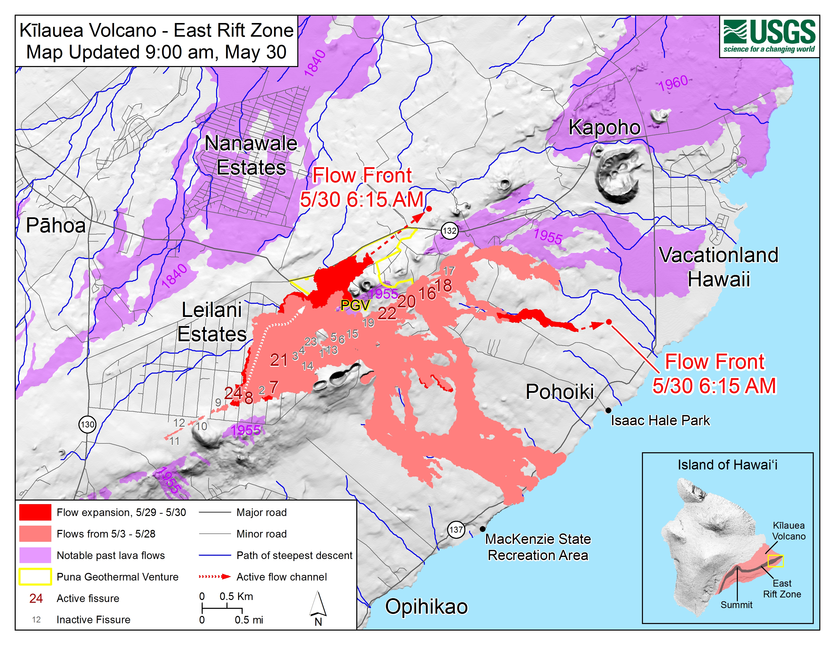
The Puna Geothermal Venture, a geothermal power plant that everyone was concerned about a few days ago, seems to have been mostly engulfed and appears to be toast. A Hawaiian newspaper has shown pictures of buildings at the site going up in flames. There's some concern about the release of dangerous (and stinky) hydrogen sulfide gases from the plant and its wells, but reportedly none has been detected.
It looks like Pohoiki is in danger of being cut off if the new flow-front reaches the sea. They are advising residents of Kapoho and Vacationland that they might want to consider evacuating too. See here. The state of emergency has just been extended.
Last edited:
That's already old. Lava is nearing the 137/132 intersection near Kapoho, and they are evacuating all the communities to the east.The flows are constantly evolving. Here's the latest map that the USGS has put out.
RainbowSingularity
Valued Senior Member
i wonder if the all seeing power of capitalism is fevorishly busy re-housing these unfortunate citizens.
i doubt it very much.
i think the main-land official response is to try and ignore it and hope it goes away.
http://fortune.com/2018/05/07/hawaii-volcano-insurance-crisis-kilauea/
what if the current state of activity lasts for 10 years ?(just as an example)
the usa has its own refugees. how it responds will be very interesting.
i doubt it very much.
i think the main-land official response is to try and ignore it and hope it goes away.
http://fortune.com/2018/05/07/hawaii-volcano-insurance-crisis-kilauea/
“As far as earthquake coverage or specifically named like a volcanic eruption, no most people would not have that kind of coverage,” Marc Dixon, an Allstate insurance agent who services the Big Island, tells Hawaii News Now.
what if the current state of activity lasts for 10 years ?(just as an example)
the usa has its own refugees. how it responds will be very interesting.
Hmm. The "all seeing power of capitalism" would mean that they are selling their stories/videos and using the money to buy/rent a new place.i wonder if the all seeing power of capitalism is fevorishly busy re-housing these unfortunate citizens.
i doubt it very much.
i think the main-land official response is to try and ignore it and hope it goes away.
If there is a governmental "official response" to allocate them housing, that would be the all seeing power of socialism.
Some people in Iceland managed to stop one of those flows, by cooling the front with seawater: https://bogbit.com/sea-water-cooling-of-lava-in-iceland/
Gawdzilla Sama
Valued Senior Member
The USGS slogan is certainly pertinent. 
Yazata
Valued Senior Member
That's already old. Lava is nearing the 137/132 intersection near Kapoho, and they are evacuating all the communities to the east.
Hawaii Civil Defense says: "Hawaiian volcano observatory reports that vigorous lava eruptions continue on the east rift of Kilauea. Fissure 8 is very active and producing a large, fast-moving flow. The flow front is half-a-mile above the Four Corners area, and moving quickly. At the present rate, it is possible the lava flow may cross Government Beach Road near Four Corners within 7 to 10 hours."
http://www.hawaiicounty.gov/active-alerts
They add: "Residents in Vacationland, Kapoho Beach Lots and in areas near Highway 137 are advised to evacuate now. Traffic is flowing both ways to allow evacuation. Residents should complete evacuation by 2:00 this afternoon, or risk the possibility of being isolated."
The most up-to-date lava location information that I've seen is on this map from Hawaii Civil Defense. I believe the green squares might be police roadblocks (not sure) and the roads in blue are closed or restricted access.
https://hawaiicountygis.maps.arcgis...ndex.html?id=3428cd9282ff431c865eb32761793078
It's pretty current and has lava sightings up to 7:00 AM Hawaii time. (I think that's about 3 hours ago). Lava appears to be west (to the left) of the big ampitheater-like volcanic spatter cone near the crossing of 132/137 at Kapoho in the maps in the posts above.
Last edited:
CEngelbrecht
Registered Senior Member
Just for the hell of it: Is it possible to trigger volcanic eruptions and/or earthquakes/tsunamis using nuclear warheads?
...I would think so!
Gawdzilla Sama
Valued Senior Member
There were proposals for "earthquake bombs", but I don't know of any actual tests. Large earthquakes release huge amounts of energy and even Tsar Bomba would have trouble coming up with that power.