In 1977 my uncle had one of the first GPS systems available to civilians. He said that every so often the reported position would jump 50 feet or so to one side - deliberately designed that way so that the Russians couldn't use the technology for military purposes. (A 50-foot discrepancy could be confusing to a cruise missile.)Also there are military applications.

You are using an out of date browser. It may not display this or other websites correctly.
You should upgrade or use an alternative browser.
You should upgrade or use an alternative browser.
Absolute coordinate system of GPS satellites
- Thread starter Saint
- Start date
Center of the Earth? Seems totally impractical. Wouldn't the center of the earth's GPS coordinates be ANY GPS coordinates with an altitude of the Earth's radius * -1? (Assuming the Earth was a perfect sphere).What is the absolute coordinate system of GPS satellites?
Is it the center of the earth?
foghorn
Valued Senior Member
This seems to be an interesting booklet free from the UK Ordnance Survey
https://www.ordnancesurvey.co.uk/business-government/tools-support/os-net/coordinates
The link on that page is '' ''A guide to coordinate systems in Great Britain''
https://www.ordnancesurvey.co.uk/documents/resources/guide-coordinate-systems-great-britain.pdf
Quote from page 20 of booklet:
GPS positioning... My bold below...
March 2020
https://www.ordnancesurvey.co.uk/business-government/tools-support/os-net/coordinates
The link on that page is '' ''A guide to coordinate systems in Great Britain''
https://www.ordnancesurvey.co.uk/documents/resources/guide-coordinate-systems-great-britain.pdf
Quote from page 20 of booklet:
GPS positioning... My bold below...
In this section, we look at the coordinate systems used in GPS positioning, starting with WGS84. We’ll discuss GPS coordinate systems in terms of the coordinate system concepts summarised in table 1.
The datum used for GPS positioning is called WGS84 (World Geodetic System 1984). It consists of a three-dimensional Cartesian coordinate system and an associated ellipsoid so that WGS84 positions can be described as either XYZ Cartesian coordinates or latitude, longitude and ellipsoid height coordinates. The origin of the datum is the Geocentre (the centre of mass of the Earth) and it is designed for positioning anywhere on Earth.
In line with the definition of a datum given in section 3.2, the WGS84 datum is nothing more than a set of conventions, adopted constants and formulae. No physical infrastructure is included, and the definition does not indicate how you might position yourself in this system. The WGS84 definition includes the following items:
The WGS84 Cartesian axes and ellipsoid are geocentric; that is, their origin is the centre of mass of the whole Earth including oceans and atmosphere.
March 2020
Write4U
Valued Senior Member
I always thought that GPS is a result of local triangulation and expressed in latitude and longitude
Triangulation (Trilateration)
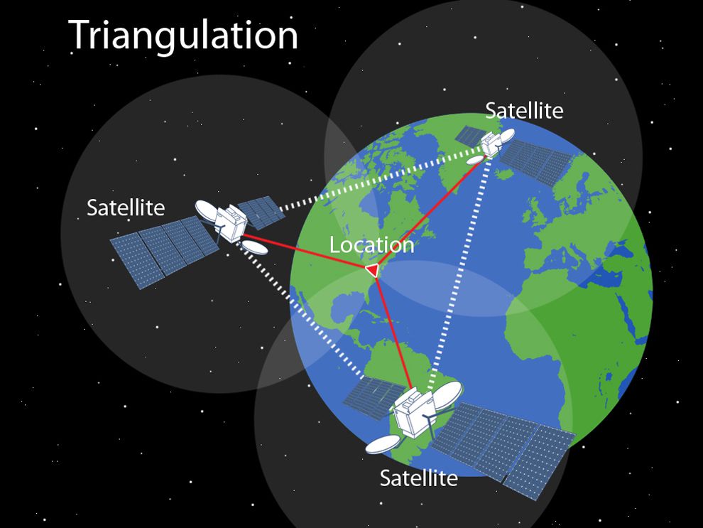
https://www.nationalgeographic.org/photo/triangulation-sized/
How Does GPS Work?
The triangulation method
1. The GPS satellites move in near-circular circumterrestrial orbits with radii near 26,000 km. The period is around 12 hours. What is the speed in the orbit?
2. Assuming that the distance between a GPS satellite and the GPS receiver is 24,000 km. What is the time delay that would be measured? (The speed of light is 300,000 km/sec)
3. The best clocks on-board GPS satellites are accurate to about 1:10-14 (short-term stability). How long (in years) would it take for such a clock to be off by 1 second?
4. What kind of timing accuracy corresponds to a position uncertainty of 15 metres.
5. The circumference of the Earth is 40,000 km and corresponds to 360°. Which angle (in arcseconds) corresponds to 15 metres?
https://www.eso.org/public/outreach/eduoff/seaspace/docs/navigation/navgps/navgps-3.html[/quote][/quote]
Triangulation (Trilateration)
A global positioning system (GPS) device uses data from satellites to locate a specific point on the Earth in a process called trilateration. To trilaterate, a GPS receiver measures the distances to satellites using radio signals. Trilateration is similar to triangulation, which measures angles, depicted in this illustration.
https://www.nationalgeographic.org/photo/triangulation-sized/
How Does GPS Work?
The triangulation method
Exercises:All of this means that a position measurement can only reach a certain maximal accuracy. In practice, under the best of circumstances, this will be about +- 15 metres for civil - still not bad at all!
1. The GPS satellites move in near-circular circumterrestrial orbits with radii near 26,000 km. The period is around 12 hours. What is the speed in the orbit?
2. Assuming that the distance between a GPS satellite and the GPS receiver is 24,000 km. What is the time delay that would be measured? (The speed of light is 300,000 km/sec)
3. The best clocks on-board GPS satellites are accurate to about 1:10-14 (short-term stability). How long (in years) would it take for such a clock to be off by 1 second?
4. What kind of timing accuracy corresponds to a position uncertainty of 15 metres.
5. The circumference of the Earth is 40,000 km and corresponds to 360°. Which angle (in arcseconds) corresponds to 15 metres?
https://www.eso.org/public/outreach/eduoff/seaspace/docs/navigation/navgps/navgps-3.html[/quote][/quote]
Last edited:
Yes. The US military for quite a while had exclusive access to accurate GPS, while the accuracy was deliberately degraded for civilian use. At some point, I guess they gave up and just decided to let everybody use the accurate system.In 1977 my uncle had one of the first GPS systems available to civilians. He said that every so often the reported position would jump 50 feet or so to one side - deliberately designed that way so that the Russians couldn't use the technology for military purposes. (A 50-foot discrepancy could be confusing to a cruise missile.)